Let me begin with the historical sites, or a couple of them at any rate, grave sites. The first one was in the delightful village of Caldbeck where I visited the grave of John Peel. John Peel must have been a bit of a character. He spent his days riding around the countryside hunting foxes with his hounds, leaving his poor wife at home looking after his 13 children! He died in a hunting accident at the age of 78 and apparently thousands turned out for his funeral. This was a full circle moment for me because at home I have a photo of the grave of John Graves, John Peel's friend and the writer of the lyrics of the song "D'ye ken John Peel", which I took last time I was in Hobart. John Graves was a maker of the grey Herdwick wool fabric that John Peel's coat was made of ("in his coat so grey") but he left his wife and took off to Tasmania where he lived the life of a " ne'er do well".

The grave of John Peel.

William Wordsworth's grave along with many of his family.

Inside St. Oswald's church at Grasmere where the Wordsworth family worshipped.

Dove cottage, near the village of Grasmere, where Wordsworth lived with his sister Dorothy, and later his wife Mary and her sister. They left for larger accommodation after their third child was born.
I left Carlisle in the sunshine, following the Cumbria Way along the River Caldew. Leaving the city I was interested to see all the flood mitigation works - flood gates installed in numerous places, and at one point I saw an early warning system for floods.
The path followed the river most of the way to Caldbeck, though I jumped out to the road a few times for ease. At about 5.00 pm I was giving myself a severe talking to for rejoining the path for the last 4kms as I slipped and slithered down a narrow, overgrown, muddy path - in the dark! I consoled myself with the knowledge that the village was within a good "cooee" distance if I needed help, but fortunately didn't!

Leaving Carlisle the sun shone.

The Cumbria Way, along the River Caldew, also doubles at times as a cycle path.

The church in Dalston, where I had a sing. So many of the churches have lych gates for shelter, but the buildings themselves don't have verandahs.

After Dalston the Cumbria Way went through farm land.......

.....and as I moved along the mountains of the Lake District got closer.

Looking back at the village of Caldbeck.
It was my plan to follow the Cumbria Way for another day, before turning off and picking up a series of back roads. This second day was well and truly in the Lakes District, and the weather promised to be fine, with a touch of sun. It began well. I had climbed the mountain called High Pike so I could get fantastic views in all directions. The trouble is, as I reached the summit so did the fog, and there were no views to be had.

The view from High Pike. All that effort and all I could see was mist!

On the summit of High Pike, about to have a sugar boost!

Looking back at High Pike. If you look carefully you can see the cairn and stool on the peak. The mist cleared after I descended!

After Lingy Hut the path became increasindownhill.y / boggy.

Lingy Hut - now a bothy, where one can sleep, but was originally a shepherds hut.

The path down from Lingy hut was hard to pick through rocks, moss, and heather. The directions were to follow the beck (stream), so at least the direction was straightforward as I headed downhill
After leaving Keswick, heading towards the village of Grasmere, I followed the quiet road going along the edge of Thirlmere, a reservoir. As I got to the far end of the Lake I saw for the first time the very special Herdwick sheep of this region which are very adaptable to the mountains. I used to buy and knit with Herdwick wool when I lived in New Zealand nearly forty years ago. It has taken that long for the penny to drop that this was wool from a type of sheep - not a brand!
It was on this leg of the journey the my path crossed the renowned long distance path, Wainwright's Coast to Coast.

Looking back towards the village of Keswick, on the shores of Derwent water.

Lake Thirlmere (above & below)


Herdwick sheep. From a distance these sheep look like they have overcoats on them, and look as if they are smiling! The lambs are black when they are born, the grey fleece being an adult colour.
After leaving Keswick I followed the coffin trail, though once it was called the "corpse road". This was a path running more or less parallel to to the road, slightly higher, and therfore a little more undulating. It is called the coffin path because it was used to carry the coffins from the village of Ambleside to the consecrated ground of St. Oswald's Church in Grasmere. This was not the only " corpse road" in the region, and as I walked I had all sorts of pictures in my mind, as there some quite steep little nips up and down!
In the village of Ambleside there are THIRTEEN outdoor stores, and it was in one of those that I decided to buy a new pack. My Aarn pack had straps that were wearing through and was no longer comfortable. The new pack is working a treat.

This is not just an ordinary stone. It is in fact a "coffin stone" or a "resting stone", one of a number placed along the way on which the coffin was placed as the bearers rested.

An interesting "bridge" at Ambleside.

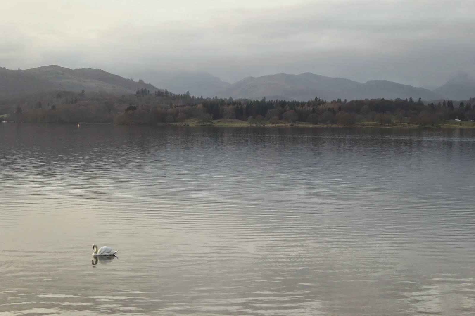
Lake Windermere (above and below) is perhaps one of the most well known of the lakes in the Lake District. Very beautiful, but even in the off season still busy with tourists.
I have met many kind and generous people in recent days. Coming off High pike and Lingy hut I realised that I would not be able to make it into Keswick in daylight. Walking in the dark doesn't bother me if it is along roads or paths where there is a defined track, but if I have a choice I don't like walking on indistinct paths out in fields or on mountains in the dark, which is what would have happened if I'd continued that day. Instead I walked out to the car park near the road and got a lift with a lady her went out of her way to take me around the mountain. The next day another vehicle stopped in a parking area as I was clinging to the walls of a very dangerous road (but here there was no alternative). She too had gone out of her way by turning around and coming back to me to see if I wanted a lift about a mile down the road into Grasmere. Was I glad to get into her car and off that road!
My third angel/s in as many days was Heather and her husband Alan. Heather designed the Pacer Poles which I use. They invited me to stay at their place, collected me from Windermere, fed me and shared their home with me, and helped me plan the next few days on quiet back roads. Heather came out with me the next day to check my pacer pole technique, and set me on the right path. It was so nice to meet the designer of such a special bit of equipment, and a lovely interlude.

Heather and I heading off, with Lake Windermere in the background.

Leaving Gilpin Bridge.


 Levens Hall, and a glimpse of some of the topiary, much of which is hundreds of years old.
 The Wheatsheaf Hotel, my place of abode in Beetham.
 Looking across the valley on the way to Carnforth.
 The Lancaster Canal (above and below).

Walking towards Lancaster I passed Levens Hall, famous for its topiary garden. Unfortunately it was hidden behind a high wall. I actually stayed in Lancaster an extra day, caught the bus back to Levens Hall to see the gardens, open for free. Unfortunately, it was not the topiary garden, though I did look over the wall from the top of the double decker bus. Walking along the Lancaster canal made for easy walking, which is just as well as the last three miles were in the dark!
I stayed the last night before Lancaster in a gorgeous village of Beetham. I'm now in limestone territory, and the buildings here were of grey limestone. The special thing for me was that my room looked out on the church, its clock chiming every quarter hour, and striking the hour, all through the night, somewhat muted compared to places in France and Spain, but it made me feel quite at home!


.jpg)


