A circuitous route to Santiago de Compostela, Spain. Stage One beginning in Munich, Germany ending in Jerusalem - traveling through Austria, Italy, Albania, Macedonia, Greece, Turkey, Cyprus and Israel. Second stage from Vienna, through Germany, Czech Republic, Holland, Belgium, France and Spain.
Final destination - Santiago!

Post Script: The changeable situation in Jerusalem has led to a change in plans. The Rome to Jerusalem leg of this journey has been changed to the 'End to End' in the UK, after which the journey will resume as above in Vienna.

Wednesday, 15 October 2014

The West Highland Way - part one

Day  Fort William - rest day, shopping.
Day  Fort William to Kinlochleven, 27.5 kms
Day  Kinlochleven to Inveraron, 30.6 kms
Day  Inveraron to Tyndrum, 15 kms

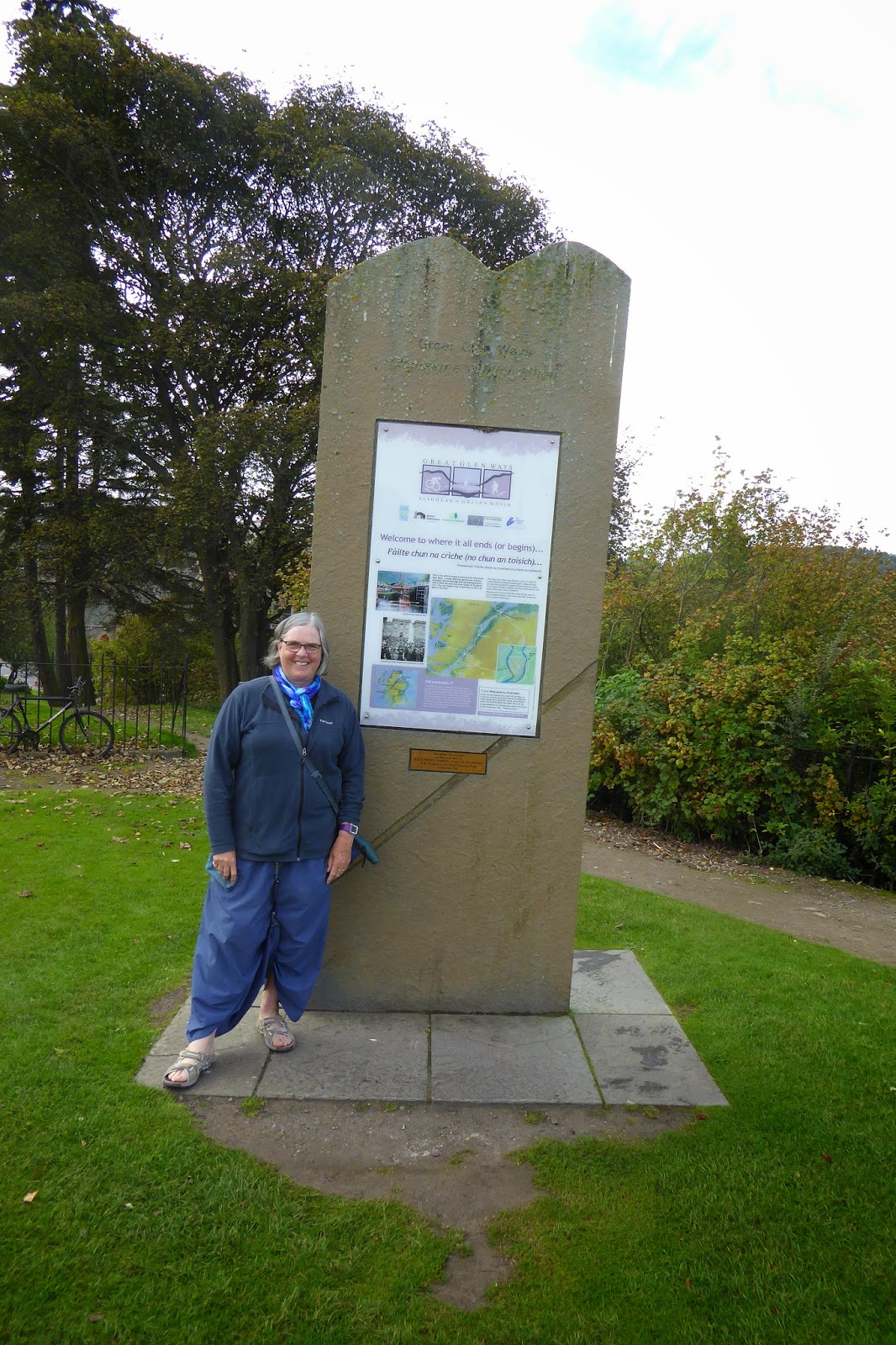
What a way!  The people, the places, the views, and even the weather.  This is a spectacular long distance path, which seems to take people somewhere between 6 - 8 days, though there are of course the intrepid few who do it in 4 days, and those who take even longer.  It has taken me 7 days, though I will tell you the story in two bites.

WiFi on this route is often not available, or alternatively so slow that I have given up on it before I have looked at my emails!  This is why you haven't heard from me.

Ben Nevis is rarely seen without its cloud hat, but last week when I left Fort William it was not only hatless, but bathed in sunshine!  I was kicking myself that I had taken note of the weather forecast and decided there would have been no point in ascending the mountain and gone ahead and booked accommodation ahead for the night.

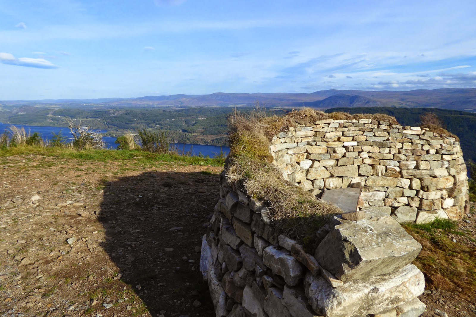
I reluctantly passed the turn off to the "Ben", and continued on up beautiful Glen Nevis.  Cars followed along the river, but the walking path quickly started to climb up through the forest.  Here I took a diversion to a 2,000 yr old vitrified fort - Dun Deardail.  I couldn't see much of the fort as it was pretty much grass covered, but I got a wonderful view up the glen, and across to Ben Nevis.  Well worth the detour.
The path turned right and went uphill just after the Glen Nevis visitor centre, where the Ben Nevis ascent begins (or the tourist one at any rate).
Ben Nevis on the right, with the town of Fort William in the gap on the right.

Part of the view from Dun Deardail, and the path leading up to it.
Looking further up the Glen, away from Ben Nevis.
The path was at times narrow and the way was slow becauae I kept stopping to look back and admire the view!

On reaching the top of this part of the path I followed the way down with high mountains on either side.  There are still a lot of people walking this way, though I think I have been the only one going my way.  People stopped and chatted with me and so it took even longer to reach my destination, with darkness not too far away when I reached Kinlochleven.  

As well as the music of the small streams, waterfalls, and bigger rivers as they tumbled down the mountains and alongside the path, as the gloaming closed in, my ears were filled with the roaring of the stags up on the slopes.  I couldn't see them, but they were very vocal, as they were over the next few days.
Grasses, heather, and bracken covered the hill sides.

Unfortunately the iconic Kingshouse Hotel was fully booked and so I had to go on, almost doubling the distance for the day.  It was probably the hardest day.  

Kinlochleven was an aluminium town, which needed a lot of electricity.  On pay day workers building the Blackwater dam used to pop across the mountain for a wee dram and then find their way back.  The problem was that many did not make it back again, because not only did they have to deal with often atrocious weather, but the only way across the mountain was over a saddle they called the Devil's Staircase.  A combination of intoxication and weather meant many met their demise.  
 Looking back towards Kinlochleven, on the way to the Devil's Staircase.
 Looking towards the Devil's Staircase, but there is more to go when I get there!

Why am I telling you this you ask?  Because this (not the intoxication bit) was what I faced on the second day, going against the flow and the harder way.  This took me a lot longer, making me in turn later for the whole day, and added to by the number of really interesting people I stopped and chatted to.  At the top of the Devil's Staircase I met two "mad Englishmen" - their description, not mine.  We shared a few laughs together before heading off in opposite directions.
The two fun "mad Englishmen" on top of the Devil's Staircase.
Wild deer at Kingshouse Hotel


One of the most beautiful sights I have seen on this way is Rannoch Moor, the next part of my day after the Devil's Staircase.  This area reminded me of a giant sponge, the sphagnum moss absorbs and holds so much water.  There was no fear of me taking a wrong path, or wandering off onto the moor - one step and I would have been up to my knees, or higher, in bog!  I was amazed that I had the good fortune to cross this bronzed (the dry bracken), cold, bleak, and desolate place without one breath of wind.  This is a real rarity because it is so high and exposed the winds whistle around most days there.
The extraordinarily beautiful, but bleak Rannochbleak,

 Rannoch Moor at sunset.

It was dark by the time I came down off the moor, and as I walked along the road to the hotel I could see moving shadows on the distance.  As I got closer I could see that they shadows were deer, one of them with the antlers of a big stag.

Over dinner that night, in the bar, I met a game keeper and his deer stalker friend.  I had a great night chatting to them, learning, among other things, how important deer stalking is for the environment.  If the deer and goat population aren't managed there would be a massive environmental problem (I guess in the same way deer created havoc in the Alps in NZ).  Interestingly, another thing I learnt was that Rannoch Moor rises by 3 cms every year - something to do with compression and the ice age!

With two really tough days behind me, I decided to have a couple of shorter, easier days.  This third day was so easy that I even had time for a leisurely coffee and cake at the historic Bridge of Orchy hotel before heading off to the little village of Tyndrum.

WiFi has run out and so more next time.


Tuesday, 7 October 2014

The Great Gen Way - part two.


Day 15, Fort Augustus  to Invergarry, 24.6 kms.
Day 16, Invergarry to Spean Bridge, 27.8 kms
Day 17, Spean Bridge to Fort William, 17.2 kms

With no high routes to choose in the past three days, and with walking along the the Loch and the canal the going has been pretty easy.   Mind you gale force winds and heavy rain made the last days walk along the canal less pleasant than it might have been.
I had to dress up against the rain.  My coat is flapping in the wind, and I am standing in the shelter of the Lock worship!

It is interesting that despite the fact that the season is closing and therefore not as many walkers are about, accommodation was quite hard on a couple of occasions.  My hosts couldn't work out why, but on arriving at Spean Bridge, the only place where I could get a room and 6 kms out of my way (I hitched part way there, thus shortening a very long day!), I think I discovered the reason.

When I went to the pub after checking into my room I came across 4 people attired in walking gear and struck up a conversation with them.  It turned out that they had been walking up in the hills and though they didn't specifically say I think they may have been scaling a few Munro's. At breakfast the next morning I met two blokes from the Midlands, staying for the weekend so they could cross a few Munro's off their list.  Strong winds overnight and into the morning meant that their plans were stymied (so I prevailed on them to give me a lift back to the path).  Thus the reason for no vacancies in the B&B's I suspect is a final push from the Munro climbers before the weather turns seriously wintery.

This lack of accommodation meant that I had a detour to Invergarry, a tiny little village, with a church, a pub, a few houses and the hostel I stayed in.

From Invergarry the path follows down Loch Lochy.  This Loch has a very interesting history, apart from its size, it is famous for being the area where the British commando's basically began.  As I followed the Loch shore down I was able to read information boards telling the story of their strenuous training on, and around, the loch.  On the outskirts of Spean Bridge a memorial to them stands, and inside the pub photographs line the wall with the story of the men, the leaders, and the place.  Here in Fort William the fabulous Highland Museum also has a whole room detailing their story.


 Loch Lochy.  It is hard to imagine this place as a training ground during the second world war.  The trainee commandos had to storm these peaceful beaches under live fire, where those doing the shooting were"skilled at missing, but not by much"!
At the far end of Loch Lochy, if you look hard, you can see the glimmer of Loch Ness.

On these last days on the way to Fort William, there were a number of very interesting things on the canal.  One was the original swing bridge at Moy, which is still in use.  There were many swing bridges on the canal, but this is the only original one left.  The lock keeper's cottage had a tiny window in the bedroom so that he could see from his bed if a boat was coming.  Not sure what would have happened if he was asleep!  It was his job to open one side of the bridge, then he had to row across to the other side and open the other side of the bridge, presumably repeating the exercise once the boat had gone through.
 The Bridge of Moy, which enabled Moy Farm to operate on both sides of the canal.

Further back near Loch Oich I walked across the double cantilever suspension bridge known as " The Bridge of Oich".  Now only curious pedestrians walk across and admire the view of the River Oich as traffic stopped using it in 1932 when the road was re routed.  Like the Caledonian Canal, this bridge is classified as an ancient  monument.
 The Bridge of Oich.  Back in the 1830's the original stone bridge spanning the River Oich and was replaced by this double cantilever suspension bridge.

Just before reaching Fort William the way goes past a series of eight locks, known as Neptune's staircase.  This is a flight of eight locks, allowing boats to rise (or fall) 19.5 metres in a distance of 457 metres.  For a boat to pass through these locks is not a quick process, normally taking one and a half hours.

Neptune's staircase, near the end of the Caledonian Canal a few kilometres from Fort William.

As I hope I have shown you, I saw wonderful scenery, interesting monuments and found interesting information along the way.  Some of it was heading towards hard, and other parts very easy.  The weather, on the whole, was kind to me.  Here in Fort William I ended the Great Glen Way, and tomorrow I start the West Highland Way.  My wallet is now considerably lighter as I have had a shopping spree in the outdoor shops.  I have looked hard at my boots and decided they should see me to the end of the new path, and with luck as far as Edinburgh.  That will be my next big expenditure.
 The marker sign at the end (or beginning) of the Great Glen Way........
 ..........and the start (or end) of the West Highland Way.

I had planned to become a tourist for a few days and head over to the Isle of Iona.  However, the prospect of reasonable weather i.e. not pouring rain or gale force winds, over the next few days as tempted me to keep walking.  I will review my Iona plans when I get to Glasgow.

I had thought I might climb Ben Nevis, Scotland's (Britain's) highest mountain, but decided against it as the mist sat on its summit, like a hat, most of the day.  If I climb something I at least want to be rewarded with a great view!


Monday, 6 October 2014

The Great Glen Way, part one.

Day 12 - Inverness to Drumnadrochit, 33 kms
Day 13 - Drumnadrochit to Invermoriston, 27.7 kms
Day 14 - Invermoriston to Fort Augustus, 13.4 kms

Fortunately I had asked someone to take this photo on Sunday because when I actually set off from the Start / Finish of the Great Glen Way there was no one around at all.
Near the start / finish sign were these signs, two going in opposite directions!  I went right and followed the signs through the islands in the River Ness and up the hill.

Setting off from Inverness on Wednesday the weather looked quite threatening, and indeed I had only gone a couple of kms when I had to put the rain coat on, but it was just a brief shower, and for most of the day I walked rain coat free, though I had to make sure it was anchored right onto my pack as once I got up above the tree line the wind was very strong.
As I walked along the moors, I passed this old the marker post.
This was very boggy country, nigh on impossible to find a dry campsite even if I wanted to!

The path is very well way marked, with just a momentary confusion occasionally as to which way to go.  The signs are a tasteful blue, making them harder to see than the yellow arrows of the Camino, but it is surprising how quickly ones eye gets accustomed to the more refined  and subtle markers.  One of the great things about this path is the way there are information posts along the path giving relevant information about the area I have been walking through.  The other impressive thing is that, though the only guide books available are from south to north, the markers guide the walker in both directions - from the south and from the north.

When the path goes higher, which it does on a number of occasions, and gets above the tree line the wind has been quite strong.
Just one of the information posts I walked past on the way from Inverness, with Loch Ness in the background.
I was headed to Drumnadrochit on this first day, and had my first glimpses of Loch Ness on the way.
Loch Ness in the gloaming.  If you look carefully at the little promatory on the right you can see the ruins of Urquhart castle.

On the second day of the Great Glen Way, there are two choices to make. One is whether to visit Urquhart Castle, and the other is to choose between the high or the low road.  I visited the castle, and chose the high road.  The forecast was for strong winds and rain later in the afternoon and so I had to move with a fair bit of speed as the winds might have made it dangerous up high, and I had been told to be careful.  They were strong and I was buffeted as I walked up high, but the views were worth it.

These first two days took longer than they should have because I kept meeting people walking the other way and of course I would stop and blather! 
A floral model of Urquhart castle in the square at Drumnadrochit.
Leaving Drumnadrochit the path heads through the village of Lewiston.  It is here that one can divert and do a tour of  Urquhart Castle.
Urquhart Castle.
Looking back at Drumnadrochit.
On the high route there were a couple of shelters.  This is an S shaped one and so walkers can get out of the wind and admire the view on one side or the other.  Loch Ness is in the background.
 The high route is a purpose built path that takes the walker above the tree line mostly, but here it is dropping down through the forest and someone took time to make this "Trogg Bridge" - quite quaint.
 The path continues  downhill towards Invermoriston, passing what, to me, looked like a fossilised tree stump.
On the new high route path I frequently came across an orange fungus (also below), which looked like someone had dropped orange peel on the ground.

Just before the final descent into Invermoriston this "circle of sticks"  acts as a picture frame.  It frames a couple of Munro's (hills above a certain height).  The trouble is the sun was perched on top of them when I went past! ( see below).

The promised bad weather came in overnight, and because of that I decided, or so I thought, that I wouldn't take the high route on the third leg from Invermoriston to Fort Augustus.  However, a couple of hours later, when I got to where the path divided, the weather had improved to such an extent that I decided to again take the high road.  The sun even came out, though the wind out in the open was quite ferocious.  The views of Loch Ness were stunning, making the effort well worth it.
 The high route.
 Looking towards Inverness.  Loch Ness
Looking towards Fort Augustus, and the far end of Loch Ness.
This old bridge in Fort Augustus was designed by Telford, the engineer whose name is linked to the Caledonian Canal.  Telford was intent on making communications in the highlands better